 |
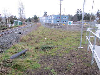
| Future site of Esquimalt Rail Station |
This site does have potential, even for a small lot. So for the last 6 months, I have been busy (besides studying for school) takeing photos, making measurements and doing sketches. I have come up with tow types of designs, glass and steel similar to a design I came up with for Langford or a marine type design to reflect the nearby naval base.
 |
| To the right and just before the buildings in the background, is my proposed site for a station. |
When I returned in early November, construction had progressed to the point where it looked like the building was almost complete. I am assuming that this building will be used by the nearby naval base, although I can't be sure for certain.
To the right is the site that I am proposing for the new station. Its large enough to accomodate a workable structure that could house a coffee shop (small) and seating. There are two new bus stops nearby (the one I am next to on the right and across the street.
Last Fall, the new intersection/crossing of Admirals Rd/Colville Rd was completed to allow safe interaction between traffic, trains, pedestrians and cyclists.
Here is a map of the site.
 |
| The red shows the potential station site with platform and the blue is the current construction site of some sort of commerical building. |
Anyway that's all for now on my first post.
Next time I will discuss the moving of the downtown station to VicWest.
Just the one thing missing... where is this lot in Esquimalt? Can u edit the post to include a Google map?
ReplyDeleteThanks for reminding me. I will add a google map, but unsure how to to do that
ReplyDeleteAdded a map.
ReplyDeleteAh interesting. I picked out the same location when surfing Google maps a few months ago. That was for LRT along the line btwn Langford & downtown, but I didnt like the route for that purpose & with no rail on the bridge, it'd be unappealing now. Only question I had was about density in that location, but I don't think that's as big a deal for the enrwy. It's not used too much for moving ppl around Victoria, more moving ppl TO Victoria, and with the navy base right there, this is the ideal spot for an enrwy station. Would likely be the preferred mode of transport to the base from north of the Malahat.
ReplyDeleteGreat work.
Correction... the enrwy SHOULD be used to move ppl to Victoria. Not sure if plans to reverse the route have gone ahead yet. Our sloth council will probably drag it out for another year or two. "Do nothing significant for the city" seems to be the theme there... and they'll probably all get re-elected.
ReplyDeleteThe ICF is planning a commuter rail run in September.
ReplyDeleteThe site has been looked at before. In fact the business council talked about building a structure with a coffee shop to serve the community linked by the rail corridor.
I am drawing plans right now.