MY VIEWS ON TRANSIT AND RAIL IMPROVEMENTS ON THE EAST COAST OF VANCOUVER ISLAND.

Monday 1 August 2011

Tuesday 26 July 2011

Comparing Two Site Options for New Vic West Staton Location

This aerial map from the Natural Atlas on the CRD website, shows two possible sites for the relocatoin of the E&N Railway Victoria Station. I favour the Kimta Rd site, as it allows for a transit exchange to be built along side the station, its closert to downtown (walking and cycling distance), it utilizes the two tracks (Catherine St doesn't have this), whichs allows room for future expansion of service.

Sunday 15 May 2011

Why we should invest in LRT and the E&N.

Victoria is unique in that we are constrained by our geographical location. This is why LRT makes sense. We cant grow outward, but we have corridors where we can direct deveopment (dense) near stations and urban centres. Another thing to remember is that we have a very high transit use compared to other cities of our size, so we can build on this.

HOV lanes simply are using a mode that created the problem in the first place, auto dependent urban sprawl. It may help in the short term, but it does nothing in terms of promoting more dense development. I am not talking about skyscrapers, I mean liviable denser communities that are within everyones reach.

Developers wont build dense development along any corridor unless they see an effort to put in a more permanent transportation system (bus or rail), although rail is seen as more permanent than bus, has a longer shelf life both in terms of infrastructure and the vehicles. This results in lower long term costs, as you dont have to replace vehicles every 10 to 15 years. Railcars tend to last 15+ years.

Another thing to consider, is that urban planning and transportation planning have to work hand and hand. If you want to control sprawl you have give developers the incentive to build more dense residential and commerical projects and not the typical single family, spread out commerical zones that are so familar all over North America.

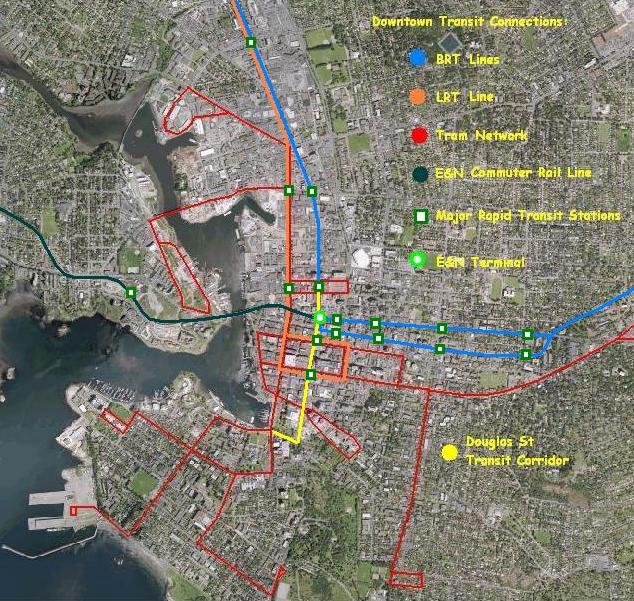
I must stress that the Douglas St corridor shouldnt be the only transit corridor. It is part of larger system of potential corridors that could serve this region. Remember its all about giving people choice. One line wont cut it, many lines will. Putting in LRT will allow buses that are currently used between Victoria and the Westshore to be better utilized elsewhere, thus improving frequency of service.

But LRT alone wont do the job. It has to be supported by good bus connections, cycling routes, walking paths, better more land efficient development. Because without these, it just wont work.

There is another form of transit, that has been overlooked it is the E&N, because its not just urban development in the CRD, its other communities up island where thousands of residents live and commute in to Victoria every day.

Dense development along this corridor could also be encouraged, especially around stations like; Esquimalt Naden Base, View Royal (at 6mile and a potential site near Hallowell Rd), Langford station Rd Transit exchange, etc.

The E&N (commuter rail) would complement LRT in the CRD in that it would link our region with other regions along the east coast of Vancouver Island with their transit systems. It would also put an end to that question of what to do with the Malahat.

The high costs of implementing LRT and fixing the E&N are worth it. Because in the long term, it will be cheaper. There are ways to deal with the funding aspects; gas revenues, help from the Provincial and Federal governments, partnering with developers, local businesses, etc. There is no such thing as "it cant be done".

When it comes down to it. All this talk of number crunching, ridership levels, funding, high costs is meaningless, because the true high costs will be associated with doing nothing and ignoring the high costs of our continual auto dependent urban sprawl which is having a profound effect on the social and environmental aspects of our urban environment.

Thursday 5 May 2011

LRT Alignment

Now that LRT has been chosen as the mode to transport commuters between Downtown Victoria and Langford, the next step is to confirm how its going to run along Douglas St and along Goldstream Ave. Then funding has to be found. The map below shows the alignment.

Thursday 28 April 2011

My website

For those of you who have been following my website, you will notice that I have changed it again. It is currently under construction, and should be up and running officially by the end of May.

Stay tuned.

Saturday 23 April 2011

New cycling trail crossing of the E&N near the transit exchange in Langford

Looks like the E&N Rail Trail has been been somewhat completed in Langford. there is crossing near the intersection of Peatt and Phillps. Here are some pics I took yesterday afternoon.


Wednesday 30 March 2011

Vic West Station

So I have included the following pictures to show the site I have chosen to relocate the Downtown Station. I am working on some drawings to show what it could look like. This site makes much more sense than moving it back to Catherine St.


Monday 28 March 2011

Rapid Transit Maps

 These are maps I did a few years ago on future rapid transit and modern tram systems for Victoria. I am planning on doing some better ones in the coming months.

Rapid Transit Line Map  I did in early 2008
I did this on in 2009 on a modern tram system

I think I did this in 2008? Its possible rapid transit routes in Downtown Victoria.

Halifax Commuter Rail

I have a growing interest in commuter rail options in Halifax, and came across this map link. Its pretty cool.
http://www.flickr.com/photos/bencnh/5536240233/

Friday 25 March 2011

Commuter Rail (E&N) vs Rapid Transit (CRD) Part One

There seems to be some confusion regarding the differences between commuter rail on the E&N and rapid transit to the Westshore via Douglas/TCH/Old Island Hwy/Goldstream. So todays post will hopefully clarify things, as there is a big distinction between the two.
 

Commuter Rail
This is used mostly for long trips with limited stations, to connect outer communities. In the case of the E&N Rwy, limited stop stations would be spaced far apart. Service would mostly be during morning and afternoon rush hour trips with some limited service in between (covered by regular intercity services). The type of vehicle that would be appropriate for such a service are DMUs (Diesel Multiple Units). These would be similar to the current RDCs being used on the line today, but would be modern and partly low floor to allow access for strollers, wheelchairs and the elderly. Refer to my picture posted on my main page on the right.

It would serve residents along the corridor, but mostly connect commuters who live north of Victoria; Shawnigan Lake, Cobble Hill, Cowichan Valley and in the Nanaimo District, as I have heard many commute from there as well.

Here is a typical map of what stations are possible on the line.


This map dating from the early 90s, shows stations at; Downtown Victoria, Esquimalt Docks, Helmcken Rd, Langford, Malahat Summit, Shawnigan Lake, Cobble Hill and Duncan.

This map that I drew up recently and shows more possible stations. Other possible stations are Atkins Rd in Victoria, a possible second station in Duncan (south) and at Drinkwater Rd. There are also possible stations in Nanaimo to serve the major shopping centres, as the corridor runs beside each of them.

The E&N Corridor

Its dishearting to see a valuable rail corridor go to waste. Yes its great to see another cycling trail being built in this region. But the problem is that cycling alone won't help our traffic woes.
The talk of commuter rail on the E&N dates back to the late 70s, in fact an article in the TC mentioned it. So the idea of carrying passengers into Victoria is not new, the only thing is its really needed right now.
In 2006 The Island Corridor Foundation took over ownership of the rail corridor and its assets and since then has tried to improve upon things. But like many projects, it needs proper funding to make certain planned service and infrastructure upgrades. Without this money, its impossible to achieve this task.
I will have more to say on this later this week.

More thoughts on transportation planning

Although I can't travel from town to town, I do attend as many meetings here as possible, plus I am very involved with the E&N Days Committee as well.  I have also been on TV, Newspapers and now Radio (mostly promoting my Grandfather's streetcar models, but I get asked on other rail and transit matters). My contacts range from developers, media, politics, post secondary, historical, to rail and transit. I have done and assisted in several presentations (most notably in front of BC Transit and the Ministry of Transportation and Infrastructure last hear.)
But I can't do it all myself, we need as many people out there pressuring our elected officials, the media and educating the general public. Just as one friend told me, we need to be as aggressive as the bike lobby, attending meetings left, right and center. :)
We need to change our per-conceived notions about transit planning. We need a holistic approach to planning our transportation future on this island. The purpose of transit and rail service on this island should not be to make money but to serve the public good (drivers and non-drivers, young and old, male and female, rich and poor), to help in improving the environmental, social and economical facets of our society. Transportation is but one of many tools to make this happen.
I guess its the chicken and the egg concept, they say you need people to ride the service, but if the service is not there, you won't have the people. I myself or anyone else is not saying that we need a service that is every 5 minutes, that is transit's job in the urban areas. A combination of tourist, commuter (that is talored to the E&N), intercity and freight services are needed (having only one won't work).
Plus I would like to say that a successful transportation system is one that uses ALL modes of travel; rail, bus, cycling, walking, taxi, car, ferry. Which means we all have to work together. Many would use the service on the E&N if it was properly provided (the current service doesn't quite cut it).

Food for Thought.

Victoria Twestival 2011

So I got to meet some really great people. Here are some pictures from tonight.


So I got to meet some of my followers and meet new followers. Here are some pictures from tonight.

The Downtown Station?

I have heard that the downtown station idea is not dead yet. so here are a few pics of where the station could be. I will have more thoughts on this later on.


Thursday 24 March 2011

Vic West Station Part 2

So I have decided on a location based on my photographs that I took on Monday. I still have to some measurements, but based on what I have seen it is wide enough for a approx. 2m (6') platform with a shelter that would cover the entire length (or individual) and  do a double duty as a bus shelter (s) as well. This is because of the narrowness of the site.


 There would be ramps for wheelchair access as well. This is because of the slightly higher elevation of the rail corridor. A platform height of about 1foot should be sufficient, that's above track height.


 So by looking at the car parked, the sidewalk would be extended the width of the car to allow an enclosed structure which would house the public washrooms and ticket counter.


Improved bus stops to allow for future expansion and service by a shuttle route linking the the station to downtown as well for current routes; #6 and #24. The picture above shows the current stop nearby.


Wednesday 23 March 2011

Transportation and Planning

The lack of integration between appropriate land use & transportion planning is one of the most irresponsible & costly mistakes. The idea that we can keep on building to satisfy the needs of the energy guzzling, land wasting automobile sets a dangerous tone for years to come.
It doesnt matter what fuel the automobile will run in the future, it still needs a lot of space to get around. There needs to be mental shift away from planning for the metal dinosaur and a return to planning our cities on a more human scale which is supported by transit, rail and cycling.
Its not just a matter of making cities more denser, its a matter of making them more livable and proper transportation planning is an important part of it. At the same time, dont just focus on the economic side, but also the social & environmental side as well when planning our urban areas.

Tuesday 22 March 2011

Vic West Station- Photo Surveys

So after hearing that rail will not be on the JSB (Johnson St Bridge), and the station being moved back to Vic West. I decided to head down yesterday afternoon and take some photographs. I do plan to do some site measurements later in the week.

Looking west along corridor with Kimta Rd on the left.

Looking East towards Victoria, with Kimta Rd on the right.


 As you can see from the next set of photos, the site is fairly narrow, ranging from approx. 3 to 4 metres, but without exact measurements I am going guessing. But its wide enough for a proper platform and modest enclosed shelter that would cover the entire length, with a enclosed narrow structure. This structure would be narrow but house space for small washrooms and a modest ticket counter. Depending on space, vending machines for food and drinks is possible.


The photographs give me an idea of the site itself (refer to the following pics) and what sort of designs are possible.

Due to the site's narrow width (approx. 3 to 4 metres), I was limited on what sort of building was possible.
This is something that I am working on, and hope to have an initial design towards the end of the week. Probably something close to heritage or modern or perhaps a combination of both.

I will keep you posted.

Esquimalt Station

Future site of Esquimalt Rail Station
Since about October 2010, I have been taking photos of this triangular site. I had originally thought of a large station with a bus exchange, but due to recent construction (you can see it on the upper left of the photo), I re-thought my original idea and changed it to include a smaller narrow station to fit the smaller site. The photo above was taken in November 2010.


This site does have potential, even for a small lot. So for the last 6 months, I have been busy (besides studying for school) takeing photos, making measurements and doing sketches. I have come up with tow types of designs, glass and steel similar to a design I came up with for Langford or a marine type design to reflect the nearby naval base.

To the right and just before the buildings in the background, is my proposed site for a station.

When I returned in early November, construction had progressed to the point where it looked like the building was almost complete. I am assuming that this building will be used by the nearby naval base, although I can't be sure for certain.


To the right is the site that I am proposing for the new station. Its large enough to accomodate a workable structure that could house a coffee shop (small) and seating. There are two new bus stops nearby (the one I am next to on the right and across the street.


Last Fall, the new intersection/crossing of Admirals Rd/Colville Rd was completed to allow safe interaction between traffic, trains, pedestrians and cyclists.

Here is a map of the site.

The red shows the potential station site with platform and the blue is the current construction site of some sort of commerical building.


Anyway that's all for now on my first post.


Next time I will discuss the moving of the downtown station to VicWest.