For those of you who have been following my website, you will notice that I have changed it again. It is currently under construction, and should be up and running officially by the end of May.
Stay tuned.
Thursday, 28 April 2011

Saturday, 23 April 2011
New cycling trail crossing of the E&N near the transit exchange in Langford
Looks like the E&N Rail Trail has been been somewhat completed in Langford. there is crossing near the intersection of Peatt and Phillps. Here are some pics I took yesterday afternoon.


Wednesday, 30 March 2011
Vic West Station
So I have included the following pictures to show the site I have chosen to relocate the Downtown Station. I am working on some drawings to show what it could look like. This site makes much more sense than moving it back to Catherine St.


Monday, 28 March 2011
Rapid Transit Maps
These are maps I did a few years ago on future rapid transit and modern tram systems for Victoria. I am planning on doing some better ones in the coming months.
 |
| Rapid Transit Line Map I did in early 2008 |
 |
| I did this on in 2009 on a modern tram system |
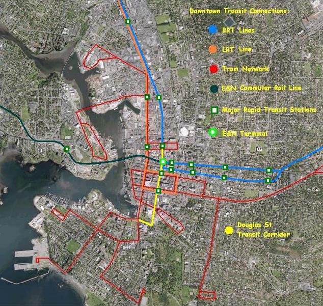 |
| I think I did this in 2008? Its possible rapid transit routes in Downtown Victoria. |
Halifax Commuter Rail
I have a growing interest in commuter rail options in Halifax, and came across this map link. Its pretty cool.
http://www.flickr.com/photos/bencnh/5536240233/
http://www.flickr.com/photos/bencnh/5536240233/
Friday, 25 March 2011
Commuter Rail (E&N) vs Rapid Transit (CRD) Part One
There seems to be some confusion regarding the differences between commuter rail on the E&N and rapid transit to the Westshore via Douglas/TCH/Old Island Hwy/Goldstream. So todays post will hopefully clarify things, as there is a big distinction between the two.
Commuter Rail
This is used mostly for long trips with limited stations, to connect outer communities. In the case of the E&N Rwy, limited stop stations would be spaced far apart. Service would mostly be during morning and afternoon rush hour trips with some limited service in between (covered by regular intercity services). The type of vehicle that would be appropriate for such a service are DMUs (Diesel Multiple Units). These would be similar to the current RDCs being used on the line today, but would be modern and partly low floor to allow access for strollers, wheelchairs and the elderly. Refer to my picture posted on my main page on the right.
It would serve residents along the corridor, but mostly connect commuters who live north of Victoria; Shawnigan Lake, Cobble Hill, Cowichan Valley and in the Nanaimo District, as I have heard many commute from there as well.
Here is a typical map of what stations are possible on the line.

This map dating from the early 90s, shows stations at; Downtown Victoria, Esquimalt Docks, Helmcken Rd, Langford, Malahat Summit, Shawnigan Lake, Cobble Hill and Duncan.
 This map that I drew up recently and shows more possible stations. Other possible stations are Atkins Rd in Victoria, a possible second station in Duncan (south) and at Drinkwater Rd. There are also possible stations in Nanaimo to serve the major shopping centres, as the corridor runs beside each of them.
Commuter Rail
This is used mostly for long trips with limited stations, to connect outer communities. In the case of the E&N Rwy, limited stop stations would be spaced far apart. Service would mostly be during morning and afternoon rush hour trips with some limited service in between (covered by regular intercity services). The type of vehicle that would be appropriate for such a service are DMUs (Diesel Multiple Units). These would be similar to the current RDCs being used on the line today, but would be modern and partly low floor to allow access for strollers, wheelchairs and the elderly. Refer to my picture posted on my main page on the right.
It would serve residents along the corridor, but mostly connect commuters who live north of Victoria; Shawnigan Lake, Cobble Hill, Cowichan Valley and in the Nanaimo District, as I have heard many commute from there as well.
Here is a typical map of what stations are possible on the line.

This map dating from the early 90s, shows stations at; Downtown Victoria, Esquimalt Docks, Helmcken Rd, Langford, Malahat Summit, Shawnigan Lake, Cobble Hill and Duncan.

The E&N Corridor
Its dishearting to see a valuable rail corridor go to waste. Yes its great to see another cycling trail being built in this region. But the problem is that cycling alone won't help our traffic woes.
The talk of commuter rail on the E&N dates back to the late 70s, in fact an article in the TC mentioned it. So the idea of carrying passengers into Victoria is not new, the only thing is its really needed right now.
In 2006 The Island Corridor Foundation took over ownership of the rail corridor and its assets and since then has tried to improve upon things. But like many projects, it needs proper funding to make certain planned service and infrastructure upgrades. Without this money, its impossible to achieve this task.
I will have more to say on this later this week.
The talk of commuter rail on the E&N dates back to the late 70s, in fact an article in the TC mentioned it. So the idea of carrying passengers into Victoria is not new, the only thing is its really needed right now.
In 2006 The Island Corridor Foundation took over ownership of the rail corridor and its assets and since then has tried to improve upon things. But like many projects, it needs proper funding to make certain planned service and infrastructure upgrades. Without this money, its impossible to achieve this task.
I will have more to say on this later this week.
Subscribe to:
Posts (Atom)